| Company Portrait | Quality System | Organigram |
| Board of Directors | Memberships |
Contact |
| Management | History |
Maps |
Land survey and land management


Location:
Principal:Ministry of Transport, Communication and Water Management Motorway Directorate
Year:1998
Revenue:
Download:
Total length of the Danube bridge: 770.42 m
Number of piers: 8
Including channel piers: 3
Total length of the bridge:22.05 m
- Geodetic survey
- Establishing network of reference points
- Setting out
- Geodetic measurements for erection of bridge structures
- Checks
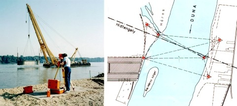
Almost each moment of the construction of the nine-span Danube bridge required geodetic checks from the first surveys to proving the residual strains of the completed bridge.
Accuracy of the located reference point network (value of mean error of co-ordinates between 0.29 cm and 0.48 cm) provided appropriate circumstances for carrying out the geodetic control tasks often requiring some specific technology. The required geodetic tasks were - among others - setting out of pile locations, control during sinking r.c. boxes at laying foundations for piers, setting out pier axes after underwater concreting, checking geometry of pier-walls, setting out seats of bearings, in addition to geodetic jobs required to the adjustment of the steel constructions of auxiliary yokes and of various other steel structures.The global control task covered the geodetic determination of plant-manufactured pier-boxes and the precise adjustment of ranging tubes fixed to the lower boxes prior to putting them into their final position.