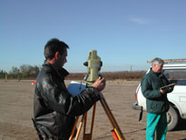
 Civil engineering has so far been symbolised with a theodolite set up in the field and an engineer standing behind the instrument. That is the way it is considered by the non-professional public knowledge, although nowadays the geodetic instruments are electronic measuring stations, working at a high measurement accuracy and speed, and also aerial photogrammetry, satellite photos and GPS systems are widely used in the surveys. An engineer also uses computer techniques and electronic units more times than optic systems during a survey, or in the course carrying out a setting-out job.
The land surveying work supplies preliminary data concerning the proposed facilities, therefore, it should be carried out with utmost reliability. The highly qualified and experienced staff of UVATERV LTD have been performing such an activity for decades, and in a manner complying with all requirements which is finally incorporated into the documentation for constructions - roads, bridges, buildings - designed by our company.
UVATERV also undertakes to perform tasks concerning land management as might be needed in the course of the design or implementation of the various constructions. Plans are drawn up for the decultivation of forests and/or cultivated areas, land acquisition plans, site plotting and replotting plans are prepared in connection with almost each of the projects.